Monday, September 30, 2024

Colorado Day 5: Mesa Verde National Park

 This was the goal of our trip, and it lived up to expectations. They don't allow tourists wandering about the cliff dwellings. You have to reserve your tour online within the last two weeks, although they are quite cheap. We signed up for Cliff Palace at 9:30 AM. We got there well ahead of time and enjoyed sitting in the shade while we waited. 

You can see the ancestral Pueblan village from the look out, but that is not the same as going there.


Along about here, I thought Steve might be considering backing out. He is at the top of a sandstone stairway.

This village of around 25 families was used for about a hundred years before it was abandoned, probably because of drought.

The doorways were tiny.

Getting out was more challenging than getting in, and the ancients did it with just toe and hand holds in the rock.

At the top we had the advantage of several ladders.

Balcony House is the other major site on that loop where you can take tours. We skipped it because there were more and higher ladders and a place where you had to crawl on your belly, but we ran into plenty of people who did both tours. Most were significantly younger than we are. I hiked to an overlook where I could see it across the canyon, but it was far enough away that pictures don't show much.

Before leaving home I downloaded an audio tour of Mesa Top Loop, narrated by a modern Pueblo Native. We listened as we drove from site to site and then investigated the site. This is Square Tower House, around AD 1200. 

Several sites were pit houses built on top the mesa, much older than the cliff dwellings. The oldest (not this one) dates from the sixth century.

Our audio tour took us from overlook to overlook.


The Sun Temple reminded us of Great Zimbabwe in Africa.

On one side there were a couple openings where we could see inside. Note the juniper beams that hold up the roof.

Here in the afternoon sun is Cliff Palace where we toured in the morning.

And at this point my phone died, no doubt due to all the pictures I had taken and listening to the audio tour without plugging in. Consequently, I have no pictures of the extensive later Pueblo villages at Fair View. We'll just have to come back. There is a whole part of the park that is closed right now for maintenance, so we have to return anyway. Besides, I think it would be cool to climb more ladders and crawl on my belly.

KFC at a patio table for supper. Tomorrow we are off to the Anasazi Heritage Center and a few lesser sites.

Sunday, September 29, 2024

Colorado Day 4: San Juan Skyway, part 1

 After a fabulous morning at Black Canyon of the Gunnison and lunch at the Rib House in Montrose, we headed south on 550, to Ridgeway, CO, and the beginning of the San Juan Skyway Scenic Byway. At first it was a nice highway in a wide valley with steep mountains on either side. Ridgeway is another of the old mining towns that are typical in the area whose 19th-century Main Street has been preserved along with a lot of delightful old houses.

But soon the valley narrowed and the road began to climb. This is the major route from Ridgeway to Durango, but it isn't fast. It IS awesome.

The town of Ouray is another of those mining towns turned tourist center. We didn't stop on Main Street for a picture, but there was a look out at the top.


We climbed over three separate 10,000+-foot passes.

It the peaks had not clouded over we would have been blinded by the glorious aspens, and I would have been begging Steve to stop for more pictures. Believe it or not these are all I took in the afternoon. 


We arrived in Cortez a little before 4:30. I'm beat. Ready for a quiet evening. Steve is watching the Lynx basketball and I'm getting ready to read my book. 

Tomorrow is the goal of our journey--Mesa Verde.

Part 2 of the Snn Juan Skyway won't be until Wednesday. Hard to believe it will be as spectacular as this afternoon.

Today's route:


Colorado Day 4: Black Canyon of the Gunnison National Park

Almighty and everlasting Father, Creator and Sustainer of the universe, I worship you...over and over today as we explore your incredible creation.

I had never heard of this park before we started planning this trip. Wow! I guess you could figure if it is a National Park it's gonna be good. (Our senior cards that get us in free were the best money we ever spent.) When we first arrived, the sun was just rising and we could see NOTHING of the canyon. So we decided to drive to the far end and work our way back.


We loved the twisted Utah junipers.

Steve not only agreed to, but he SUGGESTED, stopping at every overlook. They all involved a short, or not-so-short, walk. We realized that if we had Claudia waiting in the car, it would not have worked because you could never see much of anything from the parking lot. 


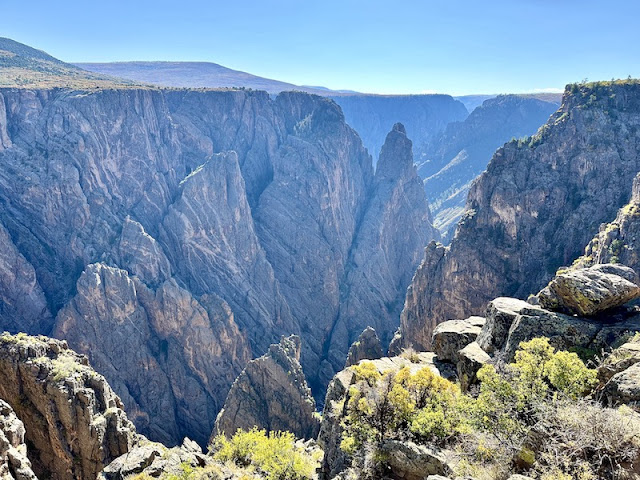
But oh! from the end of the path!!! This overlook was called "Dragon Point."

So many deep black crevasses.

DO NOT drop your phone.

Every overlook was unique, and I was grateful that Steve agreed to so many stops.


After exploring the overlook at the Visitor Center, Steve drove to the last overlook and I walked the short Rim Trail. The view was different from anything we had seen.


We could have spent all day exploring the South Rim, but we still had the San Juan Skyway ahead of us for the afternoon. I'll put that in a separate post.


Saturday, September 28, 2024

Colorado et al: Days 1-3: Top of the Rockies

In the fall of 2022 we made our last road trip west with Steve's mom Claudia. (She passed away quietly at home in February of 2024 at age 98.) On that trip we considered going to Mesa Verde National Park but discovered we were too late in the season to actually explore the pueblos. So we put it off for another trip--this one!

We began on Thursday, Sept 26, with a Minnesota Orchestra coffee concert at Orchestra Hall in Minneapolis. A couple wonderful Ravel pieces and a couple contemporary pieces we were less enthusiastic about. Another woman was sitting next to us in what used to be Mom's seat. She was sweet, and we chatted a bit. Her response to the most contemporary piece was "I can't imagine spending the time needed to practice something like that!"

From the concert, we headed to Waseca for a late lunch with friends and then on to Des Moines, continuing to Denver on Friday. Flat prairie. No pictures. But it WAS a beautiful day. Denver is NOT in the mountains, but by the time we reached the edge of the city, faint lines of blue mountains showed through the haze to the west.

This morning we took off a little after 7, headed west on I-70. Colorado is the only state I know where even the Interstate can be jaw-dropping beautiful.


At Copper Mountain we headed south on CO 91 on the Top of the Rockies Scenic Byway. Just past a major mine, we came to this valley where three mining villages thrived in the 19th century. Abandoned in the 1950s, the valley was later filled in with mining slag. One of those towns was Kokomo. My dad (who celebrated his 102nd birthday this week) grew up in Kokomo, IN, so I had to take this picture for him of the site of Kokomo, CO.

Some great photos can happen when you take a wrong turn. This one (which we thought would take us into Leadville) took us instead to a tiny community of double-wide manufactured homes with freshly painted wood siding. Every house was different, but similar enough that we suspected it was a company town. This view is from a dirt road beyond the community, which led to a dead end. Not to Leadville.

From Leadville, we continued south on CO24. Our Scenic Highways and Byways book recommended a side trip to up CO82 to Twin Lakes, a tiny tourist town of log houses and shops. We continued up 82 as far as Independence Pass where I hiked with my sister a decade ago along the Continental Divide at the top of these ridges.

On the way back to CO24 we stopped for lunch at a picnic ground along one of theTwin Lakes. The sun felt good in the breeze.

I had a note in my plans to take 306 out of the town of Buena Vista into a part of the map that is REALLY hard to read because of the small print. Colorado is NOT good at marking roads, but Steve spotted a sign that said "Cottonwood Pass" and went the right direction, so we took it. Never did see a sign that identified what road we were on but people we talked to at the top said it was 306. Cottonwood Pass turned out to be the place where my sister and I left my mother-in-law Claudia in the car with her embroidery and a book. By the time we got back to the car, it was snowing. In the weeks before she died, that was one of the memories Claudia commented on.

Here is Cottonwood Pass today. No snow.

We continued over the pass and down the other side. (We know from people we talked to that the road number changed, but never saw a sign indicating what it was.) Spectacular scenery. The aspen are at peak at elevation. When the sun shone on them, the gold color was almost blinding. We ended up following this trout stream for miles. So gorgeous.

Someone had recommended Crested Butte because of the aspen, so when we hit CO135, we turned north. The scenery was beautiful and lots of aspen, but the day had begun to cloud up so the color was not so brilliant. Then I checked the GPS and discovered that this route (all marked scenic on the Colorado map) was going to take 3 hours to get to our hotel and it was already almost 4. Uh... We turned around and took a shorter route, also scenic. (I don't think there is anything NOT scenic around here.) It only took us two hours.  :-) So much to explore; I guess we'll have to come back. :-) 

Mi Mexico in Montrose for supper.

Today's route: