Saturday, October 26, 2013

Living in the midst of History

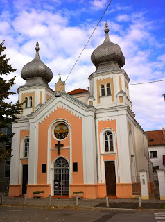
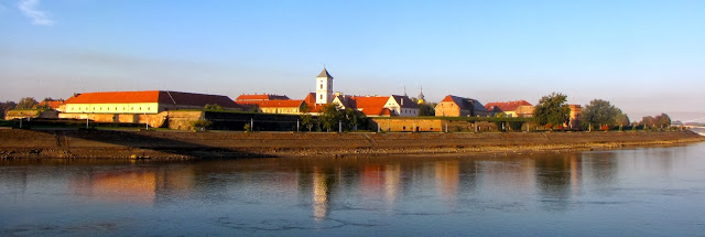
My husband and I recently spent a month in Osijek volunteering at the Evangelical Theological Seminary. See previous blogs for pictures of the school, the synagogue turned into a church, and the Cathedral in the town center. Todays pictures feature the old part of town, called the Tvrda (the fort) by locals.
Picture
Osijek, Croatia, on the Drava River, has changed hands many times over the past few millennia. The Austro-Hungarians razed the city when they forced the Ottomans out, so what you see is late seventeenth to nineteenth century.
Picture
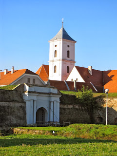
The Austro-Hungarian city was surrounded by a wall entered by this gate facing the river.
Picture
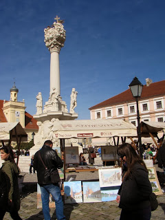
I bought a water color of the square from this vendor the morning of the monthly antique fair. One side of the square was a series of open-air coffee shops. Croatians LOVE their caffeine.
Picture
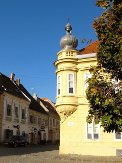
The music school is in this yellow building
facing the square. I love the sound of students practicing.
Picture
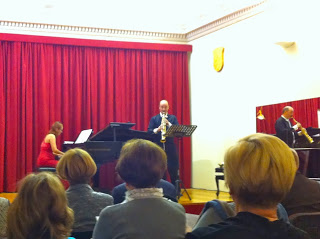
One evening we attended a free saxophone concert in the music school. The guy was awesome!
Picture
Tunnels run under the surviving fortress walls on the opposite side of the river. I found them very photogenic, i.e. I got carried away taking pictures.
Picture
Here's another attempt at a stitched panorama. I stood in the middle of the street to take this. (Left and right are really one continuous line.) I had to edit the pictures before stitching to make the corners line up properly. I think it works better with distant shots.
Picture
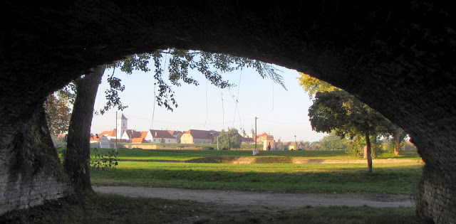
I'm partial to shooting through arches and doorways, so here is the Tvrda from the ruined walls on the other side of the river.
Tomorrow we'll see a few more pictures of life in this fascinating city, before moving to Split on the Adriatic.

Friday, October 25, 2013

For God and Country

Picture
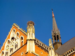
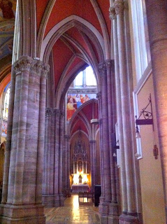
The Cathedral in Osijek, Croatia, dates from the early 19th century. We made several trips there to admire the paintings and the arches.
Picture
I got a kick out of this stork's nest on a broken pinnacle.
Picture
South aisle. The Catholic Church is closely associated with Croatian nationalism, so non-Catholics are considered unpatriotic.
Picture
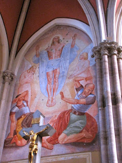
The church was heavily targeted by the Orthodox Serbs during the war for independence. Most paintings have been restored, but this one still shows the marks of shrapnel.
Picture
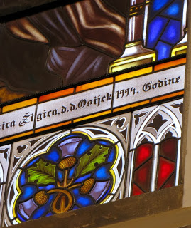
Most of the windows were broken in the shelling. 
Picture
Windows all bear post-war dates. When we were there in the 1990s everyone wanted to tell you their war stories. Now people don't want to talk about it.
Picture
I'm still trying to figure out how to use the stitch function of my camera to create panoramas. When buildings are involved, it's hard to get edges to line up because moving the camera means changing the angle. This attempt is from left to right over the crossing of the cruciform.
The city of Osijek dates back a few thousand years, although it has been destroyed many times. Monday I'll post pictures of the old town.

Thursday, October 24, 2013

A NEW KIND OF WORSHIP IN A TRADITIONAL KIND OF PLACE

Wednesday, October 23, 2013

REFLECTING THE GOSPEL IN CROATIA


Friday, September 16, 2011

North to Alaska (by boat)

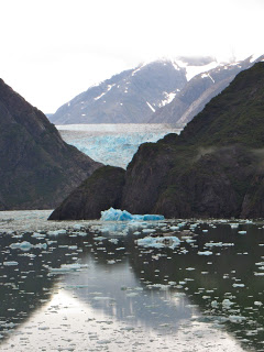
PictureSawyer Glacier at the top of Tracy Arms Fjord
What better way for my husband to recuperate from his heart attack than a cruise to Alaska? Actually, we had been planning last week’s trip for some time, and it almost had to be cancelled for rehab. We skipped Glacier National Park and Yellowstone, flew to Seattle instead of driving, and my husband promised to work out regularly in the ship’s gym. Permission granted!

Alaska is fabulous even in the rain—rugged mountains, spell-binding glaciers, forests dripping with moss and waterfalls at every turn. I broke in my new camera, trying to learn how to use a few of its many features. The song that kept going through my head was the old Swedish hymn, "How Great Thou Art."

This was my mother-in-law's trip. It  was on her “bucket list.” We were just along as chaperones. She celebrated her birthday in grand style, serenaded by the dining room staff (who sang almost as badly as the Hardy family’s traditional off-key rendition!) We attended a little white frame Lutheran church in Ketchikan, where visitors were asked to introduce themselves and tell where they are from. Afterwards a man came up and identified himself as the son of one of Mom’s close friends who passed away several years ago.
Picture
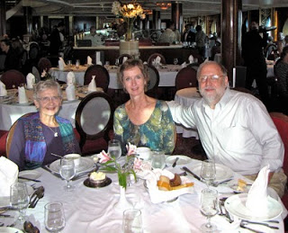
Mom, me, and my husband in the ship's dinning room
Neither Mom (age 86) nor the heart patient was up to hiking, so I was on my own to explore the Rainbird Trail along the ridge over Ketchikan. The next day I climbed Mt. Roberts behind Juneau and rode down the tramway. 
Picture
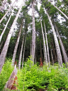
The forest over Ketchikan, Alaska
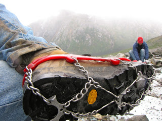
The third day I signed up for a guided hike out of Skagway. We had a private “hikers car” (no carpeting!) on the White Pass Scenic Railway, the track used by gold seekers headed for the Yukon more than a hundred years ago. We made sandwiches, fixed our lunches and disembarked at a scenic spot on the edge of a deep valley. There our guides provided us with waterproof jackets, hiking poles and cleats for managing the ice, and we headed for Laughton Glacier.
The first third of the walk was gently uphill through the rain forest. We reached the bottom of the valley where we could see the glacier above us in the clouds. This is as close as the “heli-hikes” get after flying over the glacier. We took a break for the guys to use the “facilitrees” while the girls took advantage of a $38,000 outhouse. It cost so much because all the materials had to be helicoptered in.
Picture
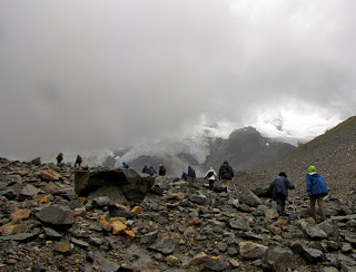
The next third of the hike was up the stony valley filled with rubble left behind by the retreating glacier. On either side were the lateral murrains pushed aside when ice crept down the valley. We climbed over a couple terminal murrains that marked the farthest advances of ice long past.

Near the top of the valley we crossed the stream. (Click link for video.) It wasn’t something I would have wanted to attempt without our experienced guides. They stationed themselves at strategic points to give a firm hand for the difficult spots. We were given the opportunity to call this the half-way point of our hike if we were uncomfortable going forward. The guide who made the offer looked straight at me as he said it. He didn’t know me very well. There was no way I would come that far and turn back short of the glacier. (I'll have you know, I was not the oldest member of our group of 16, although I’m pretty sure I was the second oldest.)
Picture
From the other side of the stream we approached the bottom of the glacier. It didn’t look white or even blue as one might expect. The surface was covered with dirt and broken rock left behind as the ice melted. Water flowed from ice caves and fed the stream we had just crossed. We moved out onto the glacier. As I stepped carefully, I kept thinking what a mess this ice would make of my figure skating blades. As the proportion of rock thinned, it became more slippery. We sat down and put on our cleats. 
Picture
We pulled out our sandwiches on the middle murrain. The guides, who sported much heavier packs than the rest of us, pulled out thermoses of hot water and packets of hot chocolate, cider and tea. One gave a demonstration of the layers in a glacier using a Snickers bar: the top layer that cracks when it bends leaving deep crevasses, the middle layer full of peanuts—I mean, rocks—and the bottom layer that slips along the valley. “The best part is the retreating glacier,” the guide said and bit off a large chunk.

Much of our walk had been in fine mist, but during lunch it started to really rain. The upper regions of the glacier disappeared in a cloud that seemed to chase us down the mountain as we retreated to the rain forest below. We were a pretty bedraggled group that caught the train returning from Canada and celebrated with homemade salmon pate on crackers. We had spent six and a half hours on the trail, going less than eight miles round trip because of the ruggedness of the terrain.

Back at the ship I headed straight for the hot tub, singing “How Great Thou Art” all the way.

[If the video link doesn't work, go to my Youtube page and click on crossing movie.] 
Picture

[Reposted from Times and Places.]

North to Alaska


 What better way for my husband to recuperate from his heart attack than a cruise to Alaska? Actually, we had been planning last week’s trip for some time, and it almost had to be cancelled for rehab. We skipped Glacier National Park and Yellowstone, flew to Seattle instead of driving, and my husband promised to work out regularly in the ship’s gym. Permission granted! 

Alaska is fabulous even in the rain—rugged mountains, spell-binding glaciers, forests dripping with moss and waterfalls at every turn. I broke in my new camera, trying to learn how to use a few of its many features. The song that kept going through my head was the old Swedish hymn, "How Great Thou Art."

This was my mother-in-law's trip. It  was on her “bucket list.” We were just along as chaperones. She celebrated her birthday in grand style, serenaded by the dining room staff (who sang almost as badly as the Hardy family’s traditional off-key rendition!) We attended a little white frame Lutheran church in Ketchikan, where visitors were asked to introduce themselves and tell where they are from. Afterwards a man came up and identified himself as the son of one of Mom’s close friends who passed away several years ago.


Neither Mom (age 86) nor the heart patient was up to hiking, so I was on my own to explore the Rainbird Trail along the ridge over Ketchikan. The next day I climbed Mt. Roberts behind Juneau and rode down the tramway. 


The third day I signed up for a guided hike out of Skagway. We had a private “hikers car” (no carpeting!) on the White Pass Scenic Railway, the track used by gold seekers headed for the Yukon more than a hundred years ago. We made sandwiches, fixed our lunches and disembarked at a scenic spot on the edge of a deep valley. There our guides provided us with waterproof jackets, hiking poles and cleats for managing the ice, and we headed for Laughton Glacier.

The first third of the walk was gently uphill through the rain forest. We reached the bottom of the valley where we could see the glacier above us in the clouds. This is as close as the “heli-hikes” get after flying over the glacier. We took a break for the guys to use the “facilitrees” while the girls took advantage of a $38,000 outhouse. It cost so much because all the materials had to be helicoptered in.


The next third of the hike was up the stony valley filled with rubble left behind by the retreating glacier. On either side were the lateral murrains pushed aside when ice crept down the valley. We climbed over a couple terminal murrains that marked the farthest advances of ice long past.

Near the top of the valley we crossed the stream. (Click link for video.) It wasn’t something I would have wanted to attempt without our experienced guides. They stationed themselves at strategic points to give a firm hand for the difficult spots. We were given the opportunity to call this the half-way point of our hike if we were uncomfortable going forward. The guide who made the offer looked straight at me as he said it. He didn’t know me very well. There was no way I would come that far and turn back short of the glacier. (I'll have you know, I was not the oldest member of our group of 16, although I’m pretty sure I was the second oldest.)


From the other side of the stream we approached the bottom of the glacier. It didn’t look white or even blue as one might expect. The surface was covered with dirt and broken rock left behind as the ice melted. Water flowed from ice caves and fed the stream we had just crossed. We moved out onto the glacier. As I stepped carefully, I kept thinking what a mess this ice would make of my figure skating blades. As the proportion of rock thinned, it became more slippery. We sat down and put on our cleats.


We pulled out our sandwiches on the middle murrain. The guides, who sported much heavier packs than the rest of us, pulled out thermoses of hot water and packets of hot chocolate, cider and tea. One gave a demonstration of the layers in a glacier using a Snickers bar: the top layer that cracks when it bends leaving deep crevasses, the middle layer full of peanuts—I mean, rocks—and the bottom layer that slips along the valley. “The best part is the retreating glacier,” the guide said and bit off a large chunk.

Much of our walk had been in fine mist, but during lunch it started to really rain. The upper regions of the glacier disappeared in a cloud that seemed to chase us down the mountain as we retreated to the rain forest below. We were a pretty bedraggled group that caught the train returning from Canada and celebrated with homemade salmon pate on crackers. We had spent six and a half hours on the trail, going less than eight miles round trip because of the ruggedness of the terrain.

Back at the ship I headed straight for the hot tub, singing “How Great Thou Art” all the way.

[If the video link doesn't work, go to my Youtube page and click on crossing movie.] 


Thursday, November 18, 2010

Travels with Claudia


 I have the best mother-in-law in the world. We recently spent a week driving cross-country together.  We both have fantasies of a simple RV.  “I’d like to be able to stop in a scenic spot, get out my lawn chair and read a while with my cup of coffee and then move on,” she once told me.  Both our husbands preferred planned routes, comfortable beds and reservations made well ahead of time.  Her husband passed away in 2004.  Mine had meetings in California after my writer’s retreat in Monterey.  

Mom met me at her daughter’s in Seattle, and we drove east.  She is a great traveling companion.  She talks, but not too much.  She checks the AAA books to find the best bargain hotels and interesting attractions.  We picnicked or split restaurant meals.  She likes her steak rare like I do and was even game to try elk.  She is as eager as I am to find out what is around the next corner.  Why didn’t someone tell me she can’t read a map?


In Yellowstone National Park we saw elk and bison, a wolf and two coyotes.  We wound up side canyons and oo-ed and ah-ed at other-worldly geothermal phenomena.  We had planned to make a loop, but the road we thought we needed was closed for the winter.  The GPS wasn’t any help because it was quite insistent that we should take another closed road going the opposite direction that would get us back to our motel by midnight.  Not exactly what we were after.  We retraced our steps only to learn when we found a ranger that the road wasn’t closed; we must have been looking at a side road.  There was nothing to do but retrace our steps again, kicking ourselves for not realizing that the road to the gate would be well-marked. 

The next day’s adventure was wholly my fault.  I bought gas in West Yellowstone before entering the park.  I hiked, and we picnicked at the Grand Canyon of Yellowstone before continuing on to Cody, Wyoming, for the night.  Cell phone reception in the park is sporadic at best.  It was only the next morning that I read the message that my wallet had been picked up a hundred yards from the west park entrance and turned in.  I must have left it on the back of the car when I pumped gas.


We had been awed by the rock formations in the Shoshone National Forest outside the east gate.  “I want to drive this from east to west next time,” I told Mom.  I hadn’t meant to do it the next day. Or return west to east the same afternoon.  It took six hours to get back to our starting point in Cody, but the scenery was beautiful. 

We slept at the top of the Big Horn Mountains that night, a serendipitous adventure our husbands would not have had with their yearning for plans and reservations.  The next night (after another map-reading adventure) we slept in the Black Hills.  The following day we picnicked at Mount Rushmore and drove through the Badlands of South Dakota in the afternoon.  (By this time I had figured out that I needed to study the map for myself.)

The last day we were tired.  Despite her 85 years, Mom had consistently refused to nap.  (“I might miss something!”)  We headed east on Interstate 90 across endless prairie, grateful we could travel faster than a covered wagon.  We made one significant stop—Marshall, Minnesota, where my father-in-law grew up.  We walked around his childhood home, trading memories of our first visits when we were engaged to the men with whom we have spent our lives. Then we tracked down the building that once housed G.J. Hardy and Sons, the bakery and grocery where Hardy’s Peanut Brittle was created. My father-in-law made peanut brittle as a child.  My husband made it as a child. My daughter still makes Hardy’s Peanut Brittle to sell between Thanksgiving and Christmas. (Keep Hardy’s handy.  It’s dandy candy!) so it is an important part of the family culture.

Now my mother-in-law, Claudia, and I are both home with memories of laughter and shared experiences and photos that only hint at the glories we saw.  The RV dream is stronger than ever, but if you don't mind, Mom, I'll read the map.