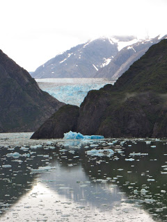
 Sawyer Glacier at the top of Tracy Arms Fjord
What better way for my husband to recuperate from his heart attack than a cruise to Alaska? Actually, we had been planning last week’s trip for some time, and it almost had to be cancelled for rehab. We skipped Glacier National Park and Yellowstone, flew to Seattle instead of driving, and my husband promised to work out regularly in the ship’s gym. Permission granted!
Alaska is fabulous even in the rain—rugged mountains, spell-binding glaciers, forests dripping with moss and waterfalls at every turn. I broke in my new camera, trying to learn how to use a few of its many features. The song that kept going through my head was the old Swedish hymn, "How Great Thou Art."
Alaska is fabulous even in the rain—rugged mountains, spell-binding glaciers, forests dripping with moss and waterfalls at every turn. I broke in my new camera, trying to learn how to use a few of its many features. The song that kept going through my head was the old Swedish hymn, "How Great Thou Art."
This was my mother-in-law's trip. It was on her “bucket list.” We were just along as chaperones. She celebrated her birthday in grand style, serenaded by the dining room staff (who sang almost as badly as the Hardy family’s traditional off-key rendition!) We attended a little white frame Lutheran church in Ketchikan, where visitors were asked to introduce themselves and tell where they are from. Afterwards a man came up and identified himself as the son of one of Mom’s close friends who passed away several years ago.
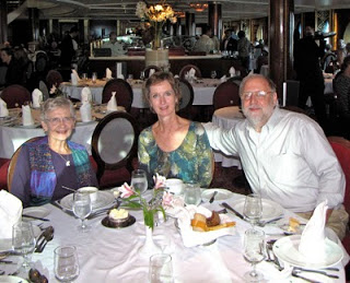
Mom, me, and my husband in the ship's dinning room
Neither Mom (age 86) nor the heart patient was up to hiking, so I was on my own to explore the Rainbird Trail along the ridge over Ketchikan. The next day I climbed Mt. Roberts behind Juneau and rode down the tramway.
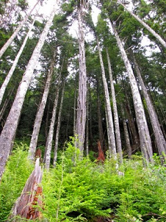
The forest over Ketchikan, Alaska
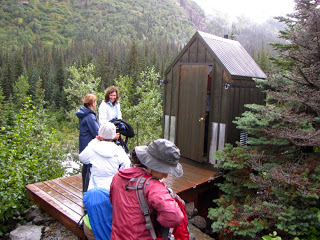
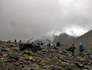
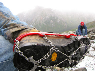
The third day I signed up for a guided hike out of Skagway. We had a private “hikers car” (no carpeting!) on the White Pass Scenic Railway, the track used by gold seekers headed for the Yukon more than a hundred years ago. We made sandwiches, fixed our lunches and disembarked at a scenic spot on the edge of a deep valley. There our guides provided us with waterproof jackets, hiking poles and cleats for managing the ice, and we headed for Laughton Glacier.
The first third of the walk was gently uphill through the rain forest. We reached the bottom of the valley where we could see the glacier above us in the clouds. This is as close as the “heli-hikes” get after flying over the glacier. We took a break for the guys to use the “facilitrees” while the girls took advantage of a $38,000 outhouse. It cost so much because all the materials had to be helicoptered in.
The next third of the hike was up the stony valley filled with rubble left behind by the retreating glacier. On either side were the lateral murrains pushed aside when ice crept down the valley. We climbed over a couple terminal murrains that marked the farthest advances of ice long past.
Near the top of the valley we crossed the stream. (Click link for video.) It wasn’t something I would have wanted to attempt without our experienced guides. They stationed themselves at strategic points to give a firm hand for the difficult spots. We were given the opportunity to call this the half-way point of our hike if we were uncomfortable going forward. The guide who made the offer looked straight at me as he said it. He didn’t know me very well. There was no way I would come that far and turn back short of the glacier. (I'll have you know, I was not the oldest member of our group of 16, although I’m pretty sure I was the second oldest.)
Near the top of the valley we crossed the stream. (Click link for video.) It wasn’t something I would have wanted to attempt without our experienced guides. They stationed themselves at strategic points to give a firm hand for the difficult spots. We were given the opportunity to call this the half-way point of our hike if we were uncomfortable going forward. The guide who made the offer looked straight at me as he said it. He didn’t know me very well. There was no way I would come that far and turn back short of the glacier. (I'll have you know, I was not the oldest member of our group of 16, although I’m pretty sure I was the second oldest.)
From the other side of the stream we approached the bottom of the glacier. It didn’t look white or even blue as one might expect. The surface was covered with dirt and broken rock left behind as the ice melted. Water flowed from ice caves and fed the stream we had just crossed. We moved out onto the glacier. As I stepped carefully, I kept thinking what a mess this ice would make of my figure skating blades. As the proportion of rock thinned, it became more slippery. We sat down and put on our cleats.
We pulled out our sandwiches on the middle murrain. The guides, who sported much heavier packs than the rest of us, pulled out thermoses of hot water and packets of hot chocolate, cider and tea. One gave a demonstration of the layers in a glacier using a Snickers bar: the top layer that cracks when it bends leaving deep crevasses, the middle layer full of peanuts—I mean, rocks—and the bottom layer that slips along the valley. “The best part is the retreating glacier,” the guide said and bit off a large chunk.
Much of our walk had been in fine mist, but during lunch it started to really rain. The upper regions of the glacier disappeared in a cloud that seemed to chase us down the mountain as we retreated to the rain forest below. We were a pretty bedraggled group that caught the train returning from Canada and celebrated with homemade salmon pate on crackers. We had spent six and a half hours on the trail, going less than eight miles round trip because of the ruggedness of the terrain.
Back at the ship I headed straight for the hot tub, singing “How Great Thou Art” all the way.
[If the video link doesn't work, go to my Youtube page and click on crossing movie.]


