Two nights in Flagstaff. One day to explore. Our trusty NatGeo Guide to Scenic Highways and Byways book has only two short scenic drives near here. But what a way to spend the day!
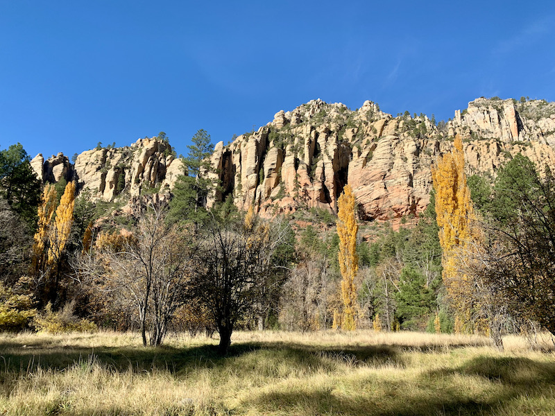
We started south on 89A for the Oak Creek Canyon Dr. The areas closest to Flagstaff, a former lumber town, are thick with Ponderosa pine.
It was hard to find any place to stop on the twisty road, but eventually we did.
On our return in the afternoon (the road was too gorgeous to only see heading south) a bride and groom were doing a photo shoot in this same field. An accident on the road had drawn police cars, fire engines, etc. By the look of it, someone was trying to oggle either the mountains or the photo shoot and rear ended a little red convertible. Both vehicles were pretty smashed, but the first responders didn't look like there had been serious injury.
On our morning stop Steve and I took a short hike while Mom read her book in the car.
Steve stepped over this critter without ever noticing him.
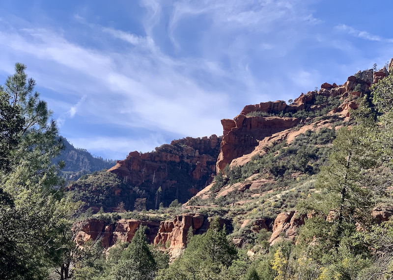
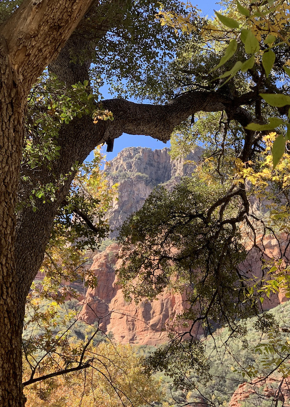
The views got more and more spectacular.
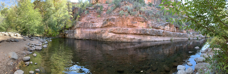
We stopped at a place called Indian Garden where the natives used to plant corn, etc...until a white man claimed it for his farm. I scrambled down to the creek.
When I returned Steve and Mom were eating scones from the bakery across the road. I joined them. Delicious. And you couldn't beat the view from the rock where I ate it.
We continued south through the very touristy town of Sedona. Lots of New Age shops made me wonder how the local churches viewed the people who ran them. Hopefully they share Jesus with respect and compassion.
We turned off on Hwy 179 for the Red Rock Scenic Byway. After gaping at the scenery for a few miles, we pulled off at a major trailhead across from this formation and more in every direction. Photos can't begin to portray it.
We are not in a hurry tomorrow, so my plan is to return here to hike and explore further in the early morning. What a place for breakfast and devotions!
We turned around in the village of Oak Creek, still touristy, but not as overwhelming as Sedona, which could easily bring on panic attacks if we had been looking for a parking space.
Stopped briefly at the Grasshopper Swimming area on our way back up the canyon. It was deserted despite the heat of the sun by that time.
To the left are wonderful rapids coming into the pool. To get here, I crossed two dry washes, which says there is lots more water in rain.
We enjoyed the scones and the Indian Garden location so much that we returned for lunch in the back patio. Delicious sandwiches on fresh bread.
We missed the overlook at the top of the canyon on the way down. It's hard to know you are about to come to a drop before you actually get to it. We stopped on the way back.
And here is a glimpse of the road we had just come up. One woman commented that it looked like a matchbox car track.
Native vendors had tables at the overlook. I bought a necklace/bracelet/earring set that I will have to model later.
The weather is cool in the shade or breeze of the overlook, but toasty warm in the sun. Steve and I enjoyed the outdoor hot tub at the hotel. Tonight it will be early to bed for me so I can make the most of the morning and be back to Flagstaff by 10:30 AM.
Most of yesterday and half of today looked like this.
But somewhere before Albuquerque the scenery began to change…and then revert to flat and boring. Good thing I was knitting to pass the time.
Steve’s sister used to teach at Thoreau Junior High. We lived in Brazil at the time and never made it out to see her there. I-40 passes right by Thoreau, so we got off and followed the signs. “Go toward the red rocks,” Patty told us. And sure enough, there it was--with a police car outside to enforce the no-entry-after-school-hours rule. (Sorry, Patty; this was as close as I could get.)
We stopped for lunch in Gallup, the nearest town when Patty was teaching here. El Rancho was another local experience. Like our Boomerang diner yesterday, it was on US Route 66. I kept thinking of my friend Stephanie Landsem’s book In a Far-Off Land, a retelling of Christ's parable about the prodigal son (or the prodigal father, as some call it) set in 1930s Hollywood. The hotel/restaurant in Gallup dates from the 1930s and hosted numerous Hollywood personalities whose pictures were all over the walls.
As if the 8-and-a-half hour drive from Amarillo to Flagstaff weren’t enough, we decided to add Petrified Forest National Park. (Love that lifetime seniors pass!) The northern section is mainly painted desert.
If only we had had time to walk some of the trails! Those are petrified logs in the foreground.
The petrified forest part in the south is full of stone stumps and even whole fallen trees turned to stone. Again, I wished for more time to explore.
We are staying two nights in Flagstaff so we have time to explore the scenic highways and byways in the National Geographic book. Steve had just turned on his computer when it beeped at him and reminded him we were traveling to Santa Fe tomorrow. Uh... That's supposed to be next week. Our snacky, crash-in-the-room supper was delayed while he got that straightened out.
Today was a driving day. I had packed picnic stuff, but it was too cold and windy at lunch time, and we hadn't seen a single rest stop with tables. When we got all the way around Tulsa without seeing a Subway (or any other franchise we recognized except McDonalds), we pulled off the tollroad at Bristow, OK. The woman in the toll booth recommended Boomerang, a local diner with a Route 66 theme, which was everything we could have hoped for.
Every table was taken when we arrived, which speaks well to the quality of the food. But we didn't have to wait long. Steve had a patty melt, Mom had a BLT, and I had the hand-breaded catfish sandwich with lettuce and tomato.
Yesterday afternoon we did our first escape room in Branson with Erika and Simeon. It was chaotic. Even with lots of hints we were on the last puzzle when time ran out. If you enlarge the above picture, you will find a word puzzle on the wall above Elvis. We joked that we couldn't escape the diner without solving it. If you solve it, let me know in the comments. I'll put a hint there in a few days for those who haven't succeeded.
I’m not feeling real motivated to blog this trip. With Covid, it has been a long time since we have done much travel, and it is a lot of work to collate pictures and write up an account every night. Mostly so far has been family stuff, but when we get out west, I know I will wish for an account. The destination is Grand Canyon—a place Mom has been but not Steve or I. We have our trusty National Geographic Scenic Highways and Byways book to suggest routes.
We spent a couple days with Erika, Dan and Simeon in Lansing, KS, to see their new home. It’s five levels. Not five stories. Each level is only a few steps up or down from something else. A bit hard for Mom to get around, but after going up eight steps, she was able to keep to one floor for the two nights, three days we were there.
Erika and Simeon and I went for a walk in a local park, but mostly it was rainy and we just hung out.
The rain followed us south to Branson. Erika and Simeon came with to the time-share we have for three nights. It is very nice with two bedrooms, two baths, full kitchen/dining room/living room. There is even a gas fireplace and three TVs.
We are not into the shows Branson is famous for, but last night at the Mexican restaurant there was a map on the wall that showed a huge lake area created by a dam in the Ozarks—well worth coming back to explore when it isn’t raining.
Erika, Simeon and I went out yesterday despite the drizzle. All Trails sent us to Lakeside Forest Wilderness Area along the river where we hiked a pleasant trail to an old homestead.
Then we started down the steps toward a cave where a local man hid during the Civil War, supplied by his wife. There were 315 stone steps. Although it wasn’t raining at the moment, it HAD been raining. We went VERY carefully.
Two/thirds of the way down we came upon a small cave.
Coming out of the cave, Simeon was very excited about a rock he had found. He wasn’t thinking about how slippery the wet rocks and leaves outside were. He went down. Fortunately, there was a level space in front of the cave and he did not go tumbling down the steps. But he did dislocate his little finger. That was the end of our hike. Instead, we went in search of an urgent care. In the car he managed to slip his finger back into place and by the time we arrived it didn’t hurt as much. He came away with an order for an X-ray if it wasn’t better, but he seems to be fine.
Tomorrow Erika and Simeon will return to Lansing, and the three of us will have a long drive to Abilene, TX, and the edge of our Western adventures.
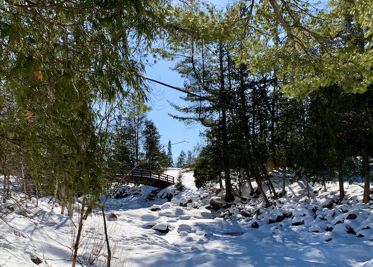
2020 was not a year for travel. So far 2021 hasn't been much better. But we have discovered that we love winter hiking! There is nothing quite like sunlight and shadows of tree trunks on white snow. A couple years ago I got it into my head to take pictures of the waterfalls at Pattison State Park (about 50 minutes up the road from here). We had been there the previous spring and I loved it, but the snow was old and yucky. I wanted to go back with fresh snow. So on a sunshiny day after a particularly big snow storm, we hopped in the car and headed north. Only they don't maintain the walks in winter at Pattison. The snow was thigh deep. Did get a nice picture of the footbridge from the road.
That was when I started investigating snow shoes. Steve gave me, not one, but two pair for Christmas this year so we could hike together.
This past week has been twenty to thirty degrees below zero. That's Fahrenheit. Thirty five below for my Centigrade friends. Today is twenty plus ABOVE! Positively balmy in comparison. The sun is shining; the snow, if not fresh, is still at least pretty clean. We headed north with our snowshoes in the car. When we got there we found that although the trails are not maintained, they are well used and trampled. (Evidently in December 2019, we came too soon after the storm and no one had broken a trail.) We didn't use our snowshoes although we wished for the cleats on the bottom at times.
We stopped at Little Manitou Falls first. I would love a picture of this with sunshine on it, but it faces north, so it is always in shadow. Any time of day, any time of year. This is probably the best I can get.
At this time of year, I could get up close and personal. Beneath that spill of ice, I could hear the rumble of water. Or maybe it was the vibration of the ice. There were no footprints across the pool in front of the falls, so I didn't try that either.
Big Manitou Falls is higher, but harder to get close to as if falls into an inaccessible gorge. Here we could see mist escaping in a few places that were not completely frozen over. Again, it faces north.
A trail goes around the lake between the two falls. We were by no means the only ones out to enjoy it on such a gorgeous day. You can see how well traveled the trail is. Also the steps turned into ramps. On the west side of the lake (return trip) there were several places where the hill was steep enough to have stairs, but they were so packed with snow that they formed 45 degree ramps. Next trip to REI we will definitely buy those spikes to put on the soles of our boots.
At the top of the lake, the trail continues along the river, but the raised slabs of ice looked treacherous.
Why did we never do this before? we are asking ourselves. Last fall the local paper had an article recommending places to walk and enjoy the leaves--places, for the most part, we had never known were there. We enjoyed exploring them, and when the snow fell, saw no reason to stop. Thank you Burnett County Sentinel!
We had almost finished the two mile circuit of the lake when we saw this sign.
Uh, oh. We had no desire to turn back and retrace our steps. In fact, with the ground frozen, there was no problem getting through. This, we presume, is the washed out bridge.
Winter hiking in the Northwoods: highly recommended. On sunny days above zero.
Hotels have taken a variety of approaches to free breakfast in these days of Covid. Some simply space tables and go at it pretty normally. Some individually wrap all items and an employee hands you what you ask for so you don’t touch the one next to it. Of course, then you put your hands all over the buttons to get juice and coffee and cereal from the dispenser (unless you use a napkin to touch surfaces.) One place provided plastic gloves, required for self-service. Others give you a bag breakfast. This one consisted of a very sticky pre-packaged grocery store sweet roll, a tiny granola bar of the cheapest chewy kind, an apple and a bottle of water, which gave heft to the bag and made you think you were getting a good breakfast. The apple was sweet and crunchy so there was something worth eating. We have been carrying our own Nature Valley granola bars, instant oatmeal, yogurts and individual fruit salads so we don’t make out too badly. I bring the electric kettle from home because I do NOT do tea made from water in a thermos or even one of those hot water dispensers that keep the water at a good temp for herbal infusions but not boiling for black tea or my favorite rooibos.
When the car was loaded (we are getting really good at what goes where!), we headed for the Badlands. Just inside the fence we turned right on the high-quality gravel road along the rim.
We paused at Robert’s Prairie Dog Town. According to the literature it is the largest in the country, covering acres and housing thousands of prairie dogs—a veritable NYC metropolitan area. We found more activity in the small town a little further up the road.
I think they are cute, but I hear my sister-in-law's voice in my head, saying with disgust, "Rodents!"
We went almost to the end of the park, ooing and ahing at the views, then turned and headed back. The asphalt with its numerous overlooks is the more spectacular. (Not surprising. That’s probably why that part of the road is asphalt. Duh.)
We stopped at Cliff Shelf for a quick hike. At the sight of this sign, Steve thought it would be cool to see a rattle snake—from a distance. I wasn't so sure.
The nice thing about the trail here is the green of the junipers to enliven pictures and rest the eyes.
At the far eastern end of the park is a large pullout with Portapotties and several trailheads, some long and some short. The best short walk is the Door, a doorway onto this incredible moonscape. Yellow poles mark a “trail.” Standing at 1, you site 2 and head in that direction. Then site 3 and head that way until you the end of the trail.
There is no distinct trail, and you can scramble wherever you choose, but the poles are like breadcrumbs that will lead you home if you keep them in sight. Twice I heard little boys, ages maybe 8 or 10, asking their parents, “Do people have to stay on the trail?” By the tremor in their voices they half wanted to stray and half feared being told they could.
When we got back to the car (where Mom was waiting with her reading and the windows open to the breeze), it was 11 AM. By the GPS, we were 10 and a half hours from home. We decided to hoof it. We cancelled our reservations in Mitchell as we drove through at 1:45 PM. Construction in Minnesota delayed us some, and we raced another fabulous electric storm the last few miles, but pulled into our driveway at 10:15 (9:15 by the time we had been living on) and got unloaded before the rain started to fall, leaving unpacking for morning.
The hours on the Interstate were not enough to finish another hat, but I got pretty far.
Our daughter and kids came up to escape the heat while we were gone. She informed us that an Eastern kingbird had taken up residence on our dock in our absence, building a nest and laying an egg in the bench cupholder. Uh… Hopefully she won’t object too much to sharing the space with swimmers.
So concludes another adventure, proving that safe travel during Covid is possible and enjoyable if you avoid the crowds in the most popular National Parks. I prefer the kind of travel where we stay in one place a couple of nights and explore the area, which was the original plan for Glacier. But we saw a lot of neat stuff. I'm glad I took my pillow. That goes a long way toward making a new bed feel normal. I would have liked fewer picnics in the car and more at pretty picnic spots. The lack was the result of crowds and the distances we had planned when we found we couldn't stay at Glacier, but we never went hungry with fruit, a tin of crackers and an assortment of Wisconsin cheese and summer sausage. When all this is over, we will try again for a real trip to Glacier.
It was a foggy morning so instead of going straight for the Needles, we headed south on US385 through the misty mountains. The fog was lifting into low clouds when we cut back north on SD87 in Custer State Park—all of it scenic. We took the wildlife loop and found a whole herd of buffalo right by the road.
Also wild donkey’s. Maybe “wild” should be in quotes since we passed a family feeding and petting one by the road—not recommended practice, I believe.
When we hit US16A we cut east and then north again on Iron Mountain Road. Steve announced this was his favorite with it's tunnels and road spiraling under itself. Of course, later in the day when we drove the Needles Highway, that was his favorite. I’d be hard pressed to choose.
I don’t think we have ever been here before in high summer. The traffic was like Minneapolis rush hour. It was still semi-cloudy and I have taken a gazillion pictures on other trips so we didn’t stop except at the Norbeck Overlook at the top
And at the Scovel Johnson Tunnel to get a picture of Mount Rushmore (that white rock just beyond where the road turns. Easier to recognize in real life.)
Traffic was heavy around Mount Rushmore as well, but if you aren’t the driver, you can still get a lot of glimpses of the giant carvings of the presidents high up on the cliff.
By then it was nearly lunch time and we headed for Sylvan Lake, back in the park. HA! Every parking space in every lot was taken as well as the road being lined with cars. We saw available picnic tables, but no place to park the car. We headed on up the road, but every pull out was full. We finally snagged a spot at the Needles Eye Tunnel.
No picnic table but the view was great!
We drove to the end of the road at US16A and turned around and drove the road again in the opposite direction. In my opinion, the SE-NW direction gives the best views of the mountains and rock formations. At least from the back seat. If you like looking from mountains into valleys, you might prefer the NW-SE route, but both are beautiful.
We spotted a DQ in Hill City and had to double back among the tourists to for our traditional summer holiday chocolate malts, but a sign on the door said, "Closed for the season." Sigh. The shop across the street reminded us that there was a major event at Mount Rushmore this week. I did not buy the T-shirt.
Our overnight destination was Wall, SD. (Skipping the drugstore in this time of Covid.) But we took the long way around and retraced our steps from yesterday back up US385 to Lead, then US14A back through Spearfish Canyon. Again, going the opposite direction gives a whole different view! Caught I-90 at Spearfish and whipped along to Wall, tired but well satisfied with the views.
Note to self: Next trip make time for a swim at the Devil's Bathtub. There was actually space in the parking lot, but returning swimmers said it is a mile hike.
Major electrical storm after supper. We have been standing in the doorway watching the amazing flashes. Tornado warning came through on our phones. Steve the Weather Nerd has been consulting the radar on his phone and says it is east of us. I can hear sirens as I write.