


Cathedral Wash in Marble Canyon, AZ, is undoubtedly the most mentally challenging hike I have ever done. Certainly alone. I have done more physically challenging hikes. (I did not come out of Cathedral Wash with my knees literally shaking like I did after one mountain hike in Korea.) But those hikes were with my son-in-law. Some of them involved ladders or pulling myself up by chains grounded in the rocks, but they were well marked, full of other hikers, and even had tea shops or souvenir stands precariously perched at the top!
And I was not alone.
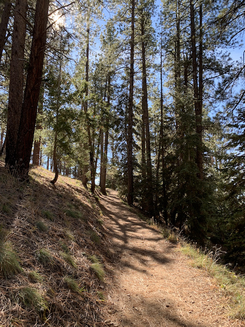
Cathedral Wash was a completely natural situation, making my way from the Lee’s Ferry road, down a slot canyon toward the Colorado River. Do not attempt without boots. Or poles. Or if you are afraid of heights.
The sun was just up when I arrived at the pull out for the trail.


I watched for footprints to give me clues as to which way to go, and was always glad when someone had prepared the way.

So which ledge will be most successful in getting me past the water without leaving me too high to get down?


At this point coming down, I chose to jump because I could see a heap of rocks that someone had piled up to be able to reach high enough to climb back up. On the return I had to reposition some of the rocks that had scattered (probably when the earlier hiker kicked his or her way up.) Even then, I ended up stretching on my stomach and kicking my right leg up to role on my belly while feeling completely overbalanced by the pack on my back.

On the way back up, I met a nature photographer coming down. I wish I could see HIS pictures! He had knee-high rubber boots with hiking-boot soles that made me jealous. If you want more images, try this page of images from other hikers although some of them show the Colorado below Lee’s Ferry at the bottom of the canyon, which I never reached.
When I got back to the hotel room, we took off for the Grand Canyon South Rim!
Our National Parks book (companion to the scenic highways book) says the North Rim can be closed in November. By the time we got to the gate (which was open), Steve said even if it had been closed, the drive would have been worth it.
Hwy 89A is not marked as scenic on our maps, but the views of the desert and Vermillion Cliffs followed by a winding mountain road through Ponderosa Pines were awesome. In fact the marked scenic byway south to the park entrance, was much less scenic with much of it having been burned over in 2000.

The park is at 8000 feet. On the climb, we saw patches of snow in the shadows, but a light jacket was fine in the sun.
“Awesome” is not a big enough word for the Grand Canyon. Everyone we met seemed to have a silly grin of delight on their face. I overheard one seven-or-eight-year-old boy as he got his first glimpse. “Whoa!” Exactly. My one complaint about the main lodge area is that there was no way to get Mom closer than eighty steps from a viewpoint. She laughed when I suggested it. Fortunately, Cape Royal allowed parking close enough for her to see, plus plenty of pullouts that were not too crowded at this time of year for Steve to pull in parallel to the curb where she could view without getting out of the car.
This is NOT the Grand Canyon. It’s only a side canyon, Roaring Springs, where we had our lunch at the only viewing point Mom could get to. Even that involved a couple steps.

Walking out to where the world drops off.

This is the Grand Canyon, or at least, one little corner of it.

Steve walked the Bright Angel Point trail, despite his fear of heights. (I later ran into a woman who refused to go out there.)


He even crossed this part. Very carefully.

While we’re doing panos, how about staying in this lodge?

Or maybe one of these cabins?

After our picnic lunch, we drove around to the campground, where Steve and Mom dropped me off to hike the Transept trail 1.2 miles along the rim back to the main lodge.
This was the perfect spot to stop for a cup of tea.

When I got back to the lodge, we headed for Cape Royal and Imperial Point, the highest viewpoint in the park at 8800 feet. Far off, you can see where the Colorado river enters the canyon.


When I said I would get up early this morning to hike, I meant early. Marble Canyon is on the Navajo reservation. That means it is not on daylight savings time—unlike the rest of Arizona. Yesterday the sun rose about 7, so I left the room at 6:30. As soon as I shut the door, I thought it was awfully dark, but I was already out and didn’t want to disturb Steve and Mom by going back in. The sun didn’t come up until about 8 this morning. It was still pitch dark when I got to this pull out. I had a nice long quiet time and breakfast before the sun began to show itself.


I couldn’t decide where to look when I got to Lee’s Ferry.

Initially, I missed the path. I started down the gravel path to where rowboats used to carry travelers across the Colorado, but, as I discovered on the return trip, the path is completely unmarked. I was making my way down the soggy riverbank and beginning to think of giving up when I noticed info plaques above me. Sure enough that was the path.

The formal trail only goes so far, but an informal fisherman’s path goes on. When I turned back, there was a whole different view of the Colorado River.

Steve and Mom were up and ready to go by the time I got back to the hotel. I made my tea, and we were off for our next adventure.
Before Navajo Bridge was built in 1922, the only way across the river was a ferry. The road to Lee’s Ferry goes between the bridge and our motel room at Marble Canyon Lodge. The road is well worth the drive, with formations both large
And small (by comparison).

There is camping and fishing and a swimming beach at the old ferry site.

A riverside trail leaves from the historic buildings at the end of the road. This one was a fort to protect missionaries and miners, although it was never attacked.

The roofed part was locked, but the collapsed portion to the right offered a chance to shoot through the empty window frames, something I can never pass up.

I plan to get up early tomorrow and come back to hike the river trail before we leave for the Grand Canyon North Rim.
Vermillion Cliffs Scenic Byway, Navajo Bridge
US 89 didn’t make our NatGeo book, but that doesn’t mean it wasn’t scenic.

It was, however, devoid of those little roadside tables announced by a picture of a picnic table under a tree. “Duh,” says Steve. “What tree?” Eventually we found a turn off with what looked like a wide parking lot outside an entrance to private property. By the trash and empty beer cans, we were not the first to use it.

I don’t usually do moving vehicle pictures but there were no pullouts. This does not do justice to the Vermillion Cliffs by any means.

The GPS was evidently having trouble finding Marble Canyon Lodge. The only address was US 89A. GPS tried to get us to take 89 (not 89A) into Utah and around to the town of Katabo where the two roads join up again. However, it said the time would be the same on 89A. Since Steve had understood the lodge was in Marble Canyon (nowhere near Katabo), we took that route.
Navajo Bridge spans the Colorado River at Marble Canyon. The roadway is on the right, pedestrian bridge on the left.

Maybe a quarter mile on was Marble Canyon Lodge, an easy walk back to the bridge. After putting in more than 5 miles this morning, I’m ready to leave that for another day. The lodge is comfortable with a nice walkway out front. Not enough outdoor chairs, so we pulled out our camping chairs from the trunk for the second time today.

[There is no Internet at Marble Canyon Lodge, so the following entries were posted after we reached the more civilized Grand Canyon South Rim.]
I was on the road a little after six and pulled into the trailhead parking lot just north of the Village of Oak Creek, AZ, about 7. Everything was still in shadow when I pulled in. I put on my boots, and when I looked up, this is what I saw.

The morning light was marvelous.

I started toward Bell Rock, but then realized that I was taking pictures of the same formations since Courthouse Butte was still in shadow with the sun behind it. When I reached the turn off for Big Park Loop which would take me to the east side of the butte, I took it and was rewarded with sun on the rocks.

Eventually I found a rock to sit and eat my hardboiled egg, granola bar and yogurt. This was my view.

The trail so far had been easy, but the N end of Courthouse Butte was marked “intermediate.” I pulled out the collapsible hiking poles I had ordered on Amazon and had sent to Erika when I realized I would be hiking in the Grand Canyon and was very glad to have them.

The sun went behind clouds, making it easier not to stop every ten steps to take another picture. The tall narrow rocks are called “Rabbit Ears.”

Mostly the trail was pretty clear. Occasionally there were places where one might be unsure what route to take, but brush hauled across the not-trail or a row of rocks directed you where to go. In the places where the trail crossed a wide expanse of flat rock, little rock turrets like this one indicted what to aim for.

I was navigating by the All Trails app on my phone. About the time I was thinking I should be seeing the parking lot in the distance, I checked the app. Ooops. I wasn’t where I thought I was. I still had a couple miles to go. I was supposed to be back to the hotel in Flagstaff by 10:30 for an 11 o-clock check out. Good thing the light didn’t tempt me to stop for pictures. I hoofed it those last couple miles, and arrived back in Flagstaff at 10:40. Not bad. I had called Steve to give him instructions on packing up my toiletries and the cooler stuff, which I usually take care of. When I arrived, everything was ready to pack the car. Mom even had her hat and coat on against the chill. (I had started the morning with jacket, padded vest, and gloves, but bit by bit had stowed them in my pack.)
Soon we were on our way north on Hwy 89.